Understanding animals through their behaviour
Understanding animals through their behaviour
I have visited Lands End twice, once in 2002 and one in 2006 with the Clifton Antiquarian Club. My new age comments are those of 2002. Since then I have become more interested in the archaeological, rather than the spiritual, significance of the sites. Archaeological sites found in Cornwall differ in style from those higher up the country. The two main Neolithic barrow types are the Penwith tombs or quoits, which are closed dolmens or portal dolmens – huge capstones with three or more uprights. The other group is that of Scillonian entrance tombs, where the passage into the tomb is not differentiated from the chamber area (like chambered tombs) and the mound has a retaining kerb. There are also long mounds, either long cairns made of stones or long barrows made of earth. These may be constructed without burials – there are long barrows without burials elsewhere in the country. There are 25 stone circles in the county, with several multiple circles, probably dating from the late Neolithic to the Bronze age. Standing stones near the circles seem part of a sacred landscape and some of the circles have a relationship with each other. For a good all-round guide read Cornwall in Prehistory by Toni-Maree Rowe. Early antiquarians reported on some of the Cornish monuments. I have quoted from Richard Carew’s Survey of Cornwall published in 1602, and from John Aubrey’s Monumenta Brittanica. Çharming illustrations (not reproduced here) are to be found in Stone Circles, Çromlechs, and other remains of the aboriginal Britons in the West of Cornwall, by William Cotton 1827 and reprinted by Ian McNeill Cooke, Men-an-Tol Studio. The latter can be bought from www.megalithic.co.uk The line drawings here come from William Copeland Borlase’s book, Naenia Cornubiae of 1872. Some are his own drawings, some he took from Observations on the Antiquities of Cornwall, published 1754 by his great grandfather Dr William Borlase (1695-1772).
 A barrow so unlike anything else, that the differences may be due to its finder, William Copeland Borlase, who re-created it. He excavated it in 1874 (too late for inclusion in his book, Naenia Cornubiae 1872). It probably started life as a Scillonian entrance grave and was extended. Several cist burials were added then or later. It is now a round cairn (its corbelled roof decapitated) with two circular stone walls. There is currently a passage between the two walls. If roofed, this would be a pitch black circular passage. A reconstructed picture of what it might have looked like somewhat resembles a reconstructed picture of a rotunda grave found under Notgrove long barrow. A very odd barrow.
The circle is mentioned in the medieval Welsh triads as one of the principal gorsedds (bardic meeting places) in Britain. There are 19 uprights one of them flat topped and made of quartz. A large centre stone is now at an angle and has two possible axe-head carvings, which I could not make out. Centre stones are found in Cork stone circles, as well as in some of the Bodmin moor circles. Not only is quartz used in the Cork stone circles, often in just one of the stones, but they often include one visibly flat topped stone like the quartz one in this circle. It’s still used as a gorsedd. Now in a walled off enclosure, this once had a hedge running through it. John Aubrey wrote: “This Mr Camden believes was a trophy of King Athelstan; but it being agreeing in its architecture with temples aforesaid (ie circles in Wiltshire) I presume this also to have been a temple.”

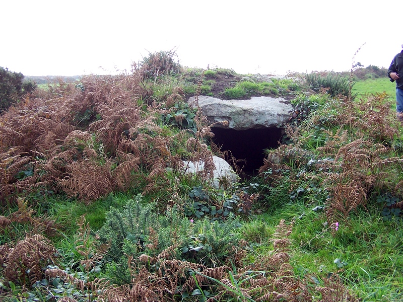
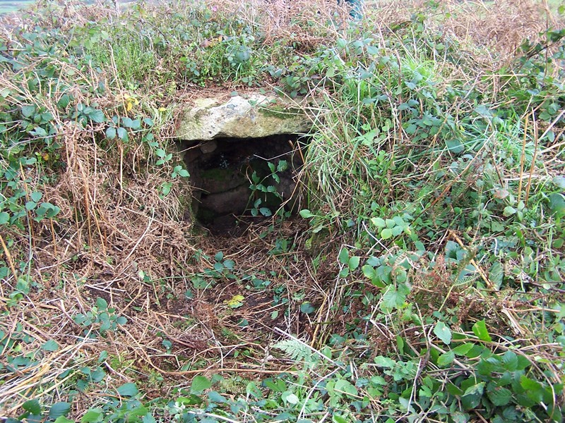
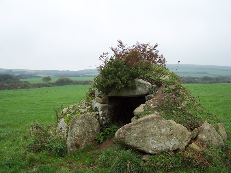 This hasn’t changed since Victorian times, when it was discovered in l863 by W.C. Borlase. It was being used as a pig and sheep shelter by the farmer. It’s a small Neolithic Scillonian entrance grave, surrounded by a peristalth of large granite stones. “It may be considered as the most perfect of its kind in the West of England,” claimed Borlase. A twee little barrow ideal for piskies!

 A beautiful site with a Penwith chambered tomb described by W C Borlase as “the most perfect and compact cromlech in Cornwall.” In l871 he described “the cairn, which in some places nearly reaches the top of the side stones on the exterior, is thirty-two feet in diameter, and was hedged round by a ring of upright stones…. very suggestive of the whole being once totally buried in the tumulus.”There is still some stone debris. This is a closed chamber without a portal. Nearby Çhun castle, an Iron age fort with walls made of stones not earth, had the remains of hut circles. It’s a glorious walk.
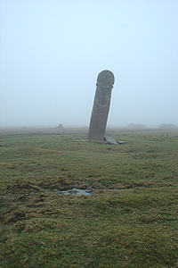
 Not far from the Hurlers, this is a broken Cornish cross with knotwork pattern and in Latin “Donert Rogavit pro anima” translated as “Donert asks for prayers for his soul.” This is probably a monument to King Doniert drowned in the River Fower when out hunting in AD 872. This monument was called The Other Half Stone in Richard Carew’s “The Survey of Cornwall” in 1602. “It should seem to be a bound (ie boundary) stone, for some of the neighbours observed to me that the same limiteth just the half way between Exeter and the Land’s End, and is distance full fifty miles from either.” Aubrey also visited King Donierts’s stone noting (wrongly) of the inscription; ” These characters are runic.” The practice of siting a Romano-British memorial stone, along a track way up on the hill is a Roman one – think of the tombs along the Appian Way.
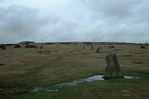
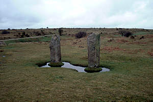
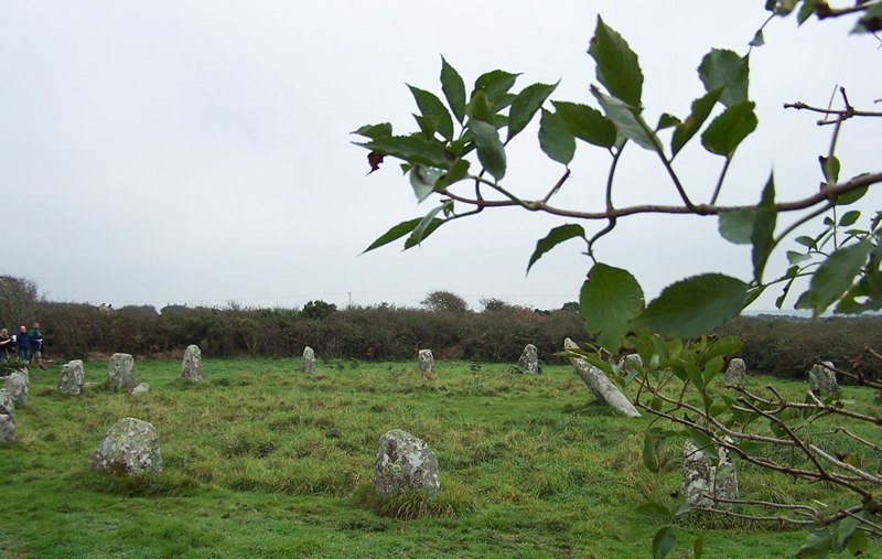
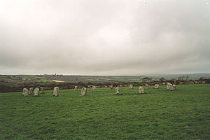
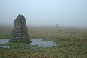 I visited the circles in thick fog on March 20 2002. They seemed huge and I dared not go further than the second circle (the first being the ruined one). It was eerie and I felt the full power and awe of a sacred place. A few days later everything was now visible and the three circles looked much smaller and less frightening. These three large stone circles were erected 2500-1800 BC. Excavations in 1935 revealed that the northern circle was paved with granite and the middle circle strewn with crystals possibly chipped off the uprights. Å granite pathway linked the two. As William Camden wrote in 1587: “The neighbouring inhabitants terme them Hurlers, as being by devout and godly error perswaded that they had been men sometime transformed into stones, for profaning the Lord’s Day with hurling the ball.” John Aubrey sketched these inaccurately, perhaps in fog! He remarks: “The Hurlers also, fabled to be men metamophosed into stones: but in truth show a note of such victory, or else are so set, for landmarks and boundaries” In 1602 Richard Carew in “The Survey of Cornwall” had described them as “certin stones, somewhat squared and fastened about a foot deep in the ground. And a like strange observation taketh place here as at Stonehenge, to wit, that a redoubled numbering never eveneth with the first.” Two paired stones, the Pipers, are close to the circle. The legend is that the pipers were turned to stone for playing on a Sunday. These are outliers to the stone circles like the taller pair found near the Merry Maiden. A little way along beside the road from the Hurlers is Long Tom or the Longstone, possibly an outlier to the stone circle. It has probably been christianised with a cross carved on the top – something similar happened to the Culbone stone on Exmoor.
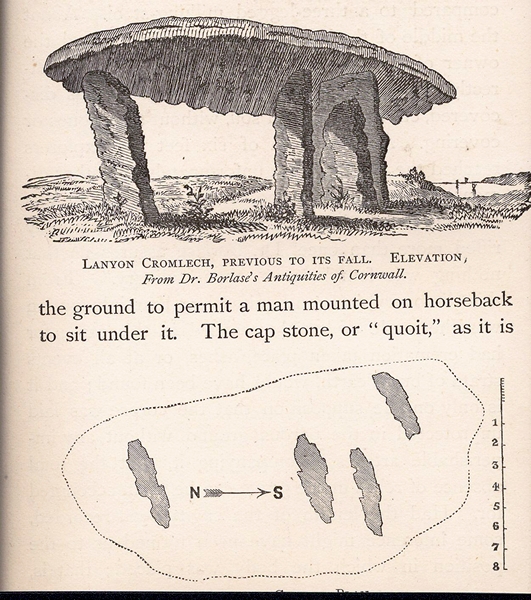
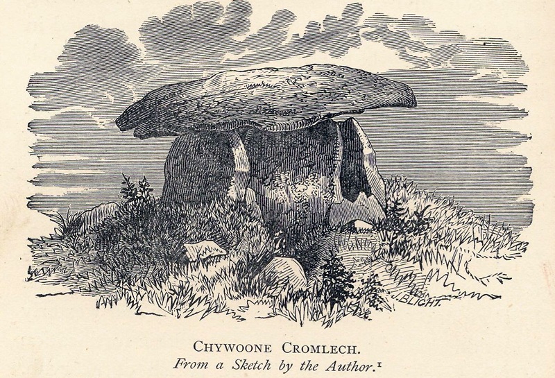
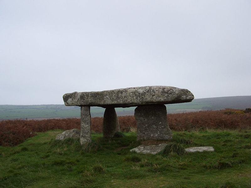 This is not the original monument. That fell down in 1815 probably because in the previous century “a dream induced the owner of the property to dig beneath it.” What we see now was re-created by Captain Giddy R.N. “whose zealous exertions overcame every difficulty and merit the thanks of all topographical antiquaries,” according to William Cotton. In the course of this, a piece was broken off the capstone and the zealous Captain Giddy levelled off the three uprights, changing their positions slightly. Dr Borlase claimed that a man on horseback could ride under the original capstone (like Pentre Ifan in Wales). His sketch shows three uprights holding up the capstone and a portal stone, much taller than the current one, between them.
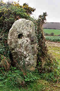
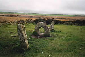 A really unusual monument, sometimes interpreted as the remains of a stone circle. The stones were set in concrete A drawing by Dr Borlase in l769 shows a different alignment to the present one – the hole stone is not in a row between the two uprights. Årchaeologist George Nash suggests another possibility, that these are the remains of a galleried tomb like Le Couperin in Jersey, with the holed stone being a portal stone between two chambers. The hole might well have been enlarged later on, when people started going through the hole (as they still do) for luck or for healing.
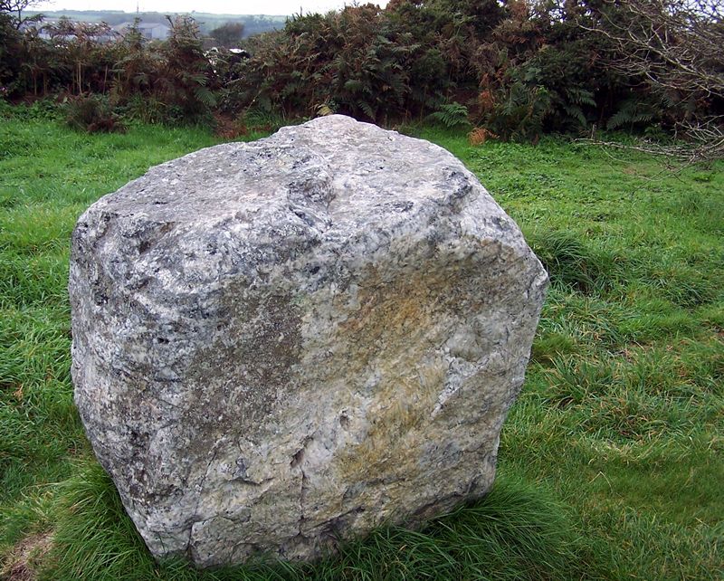
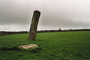
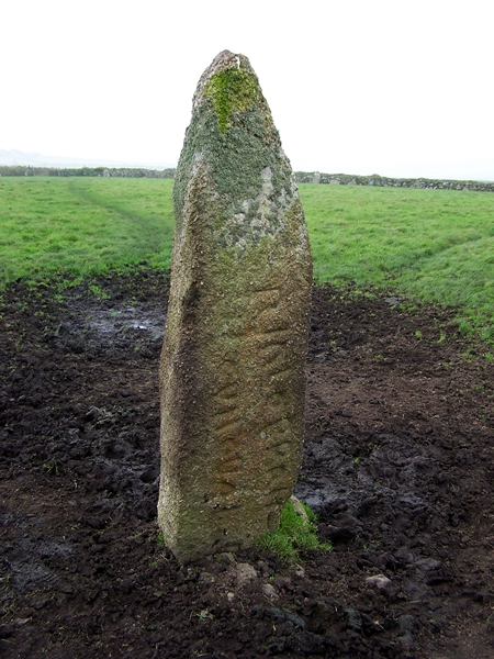 Not far from Men-an-Tol, this giant granite stone has a Latin inscription. Unlike the other inscribed stones on this website – the Caractus stone on Exmoor or the Doniert stone on Bodmin Moor, this is not (as far as one can tell) by a track or road. Archaeologist George Nash points out that the words may have been inscribed on an existing prehistoric standing stone which was originally part of the Men-an-Tol landscape. The 6th century AD inscription, now partly buried, reads RIALOBRAN CUNOVAL FIL. It was discovered lying flat and was set up by the Captain Giddy R.N. in 1824 – the same Captain Giddy that re-arranged Lanyon Quoit. In St Just parish church stands a similarly inscribed stone. It was discovered in l834 built into a wall close to the altar. This has a Greek Christ motif and a Latin inscription reading ÍELUS IC IÅCIT (Selus lies here). Even after the departure of the Romans, Latin was still the language of power and influence. Later the synod of Whitby decided in favour of the church of Rome, rather than the Celtic church, confirming Latin as the primary language of authority.
 The Merry Maidens stone circle has 19 upright stones and has three associated standing stones. The Pipers nearby may be outliers to the circle. One of them is Çornwall’s tallest menhir at 4.6 m. My photograph shows one of them, with the other just visible over the hedge. Also nearby is the Gun Rith stone. Single standing stones are difficult to date and even more difficult to interpret. William Cotton, who visited Cornwall in the autumn of 1826, declared: “ It seems reasonable to me to suppose that they (standing stones) are the remains of an idolatrous worship of the very earliest ages.” William Copeland Borlase, who dug here in l871, wrote: “By the side of this stone was found a sand-stone pebble flattened on one side and evidently used as a whetstone.” His map of the landscape shows the circle with its associated standing stones. In the gateway opposite side of the road is a holed stone, possibly another one. Most holed stones locally are associated with circles. There is a little Cornish cross not far away too. Borlase was aware that this was a complex of monuments – his map details them.


 TREEN BARROWS, Treen. SW 43l84 3710
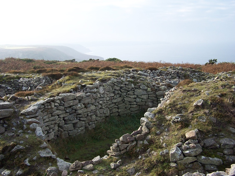
 A group of four of Scillonian entrance graves. One is easily seen, two are ruined and one (North at 438l1 3715) is hidden in bracken and bramble. They stand not far from a long mound, possibly a long barrow or long cairn, slightly higher up the hill. The Southern barrow has three capstones. The Northern one has dry stone walling (big stones) rather than orthostats.
 Just down the road from the Merry Maidens stone circle by the side of the B3315 is a Scillonian entrance grave dated 2000-3000 BC. William Copeland Borlase directed his workman to this barrow because he had time left over on March 11 l871, after digging round the Pipers standing stones and finding nothing. On digging (the workman not Borlase) they found “a very considerable quantity of bone splinters, mingled with ashes” and a small pit with more bone and ashes which was ‘lined with shell sand.” Later excavation discovered a cupmarked stone. The one visible to day, sited the wrong way, is a concrete reproduction of the original which is in Truro museum.
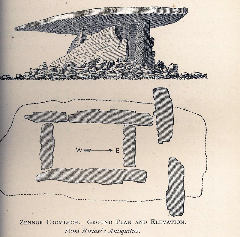
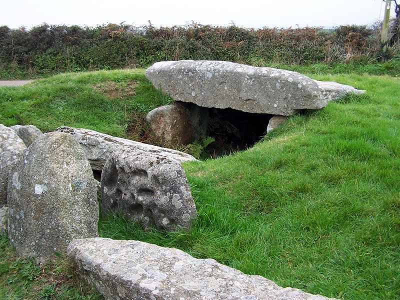
 This is a portal dolmen with monumental closed-in façade of two stones placed sideways flanking the entrance. When originally found “it was with great difficulty that a man could squeeze himself into” the chamber. We nearly lost this monument. The dolmen was rescued from destruction by a local vicar, a member of the antiquarian Borlase family. The farmer had decided to make it into a cattle shed – nearby uprights are the start of this building. The capstone has now slipped but the monument is still impressive. Luckily Dr Borlase made a drawing and plan of the original – seen here. Nearby are the ruins of Sperris Quoit at SW 47102 38268 – worth seeing while you are seeing Zennor quoit.