Understanding animals through their behaviour
Understanding animals through their behaviour
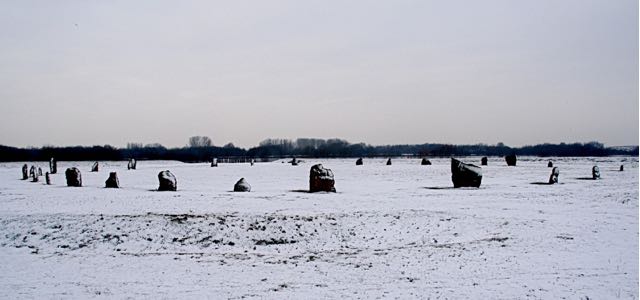
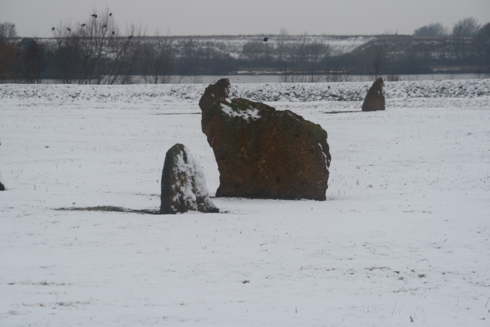
This was once one of the seven largest stone circles in mainland Britain – an oval earthwork enclosure with two entrances, a huge rampart with a berm and ditch, and 36 standing stones. Now it is a restored site, coming back to its ancient glory.
It stood in a ceremonial landscape with ring ditches, flat graves, pits and possibly a mortuary enclosure. For the best account read Excavations at the Devil’s Quoit, Stanton Harcourt by A Barclay, M Gray and G Lambrick, published by the Oxford Archaeological Unit in l995.
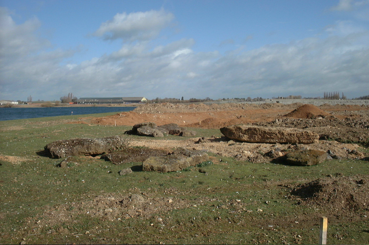
The site was severely damaged first by the plough from Roman times onwards. By the middle ages the site was the common field, divided by ridge and furrow into individual plough strips. By them most of the stones had been removed. By 1940 three stones were standing but only one in its original site and a wartime airfield was built there. Luckily an excellent archeological survey was taken before this happened. Then the site fell to gravel extraction and most of the complex has been entirely destroyed except for the henge itself.
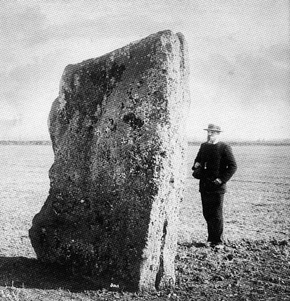
One of the first antiquarians to study this stone circle was John Aubrey who sketched two stones and reported in his Monumenta Brittanica, written in the seventeenth century, that the “east stone is nine foot high: and as much broad: half a yard thick. The west stone is eight foot high and about six foot broad, half a yard thick. One of these stones was taken down by a farmer about the year 1680 to make a bridge of.”
Richard Plot in The Natural History of Oxfordshire 1677, working from Aubrey’s notes, thought it was a Saxon barrow: “But as for the stones near the barrow at Stanton-Harcourt, called the Devil’s Coits, I should take them to be Appendices to that Sepulchral Monument (ie the Rollrights), but that they seem a little too far removed from it; perhaps therefore the Barrow might be cast up for some Saxon, and the Stones for some Britans slain hereabout (aut vice versa) at what time the town of Eynsham, about a mile off, as Camden informs us, was taken from the Britans by Cuthwolf the Saxon. Which is all I can find worthy notice concerning them, but that they are about eight foot high, and near the base seven broad; and that they seem not natural, but made by art, of a small kind of stones cemented together.” – a reference to the fact that these are coagulate stones.
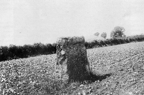
By the beginning of the twentieth century apart from three upright stones the site seemed completely flat and even O.G.S Crawford, a man with a keen eye for prehistoric monuments of all kinds and author of The Long Barrows of the Cotswolds (1925), could not believe the site was a stone circle with henge. He wrote: “The great diameter necessary (2200 feet) makes this unlikely. The diameter of the great rampart at Avebury is only 1400 feet.”
Luckily, the henge was recognized by crop marks from the air and photographs were taken by Major G.W. G. Allen. Otherwise the site would probably have been lost entirely. As it was, it was given very little protection, when the Air Ministry wanted to build a wartime airfield there.
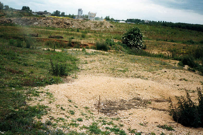
W.F. Grimes did an excellent survey of the whole site. But without visible monuments, it was given over to gravel extraction – like the equally important site at Dorchester, Oxon. Only the henge itself was conserved – even the inside of the henge was graveled out.
When I first visited the Quoits in the year 1999 it was a chaotic mess in the middle of a huge extraction and waste site, Dix Pit. The then manager knew little or nothing about it until I gave her a copy of the published archeological book.
But two years later in 2002, work was under way to recreate the circle, using the original stones and others of a similar coagulate. By 2005 several stones were standing. The site is now open to the public, by the creation of a path which avoids the gravel extraction and landfill going on all around it. The creation of a lake nearby means that the Devil’s Quoits have entirely lost their context. But at least the recreated site gives a good idea of this stunning monument.
This site is, to my mind, a good re-creation giving onlookers the chance to assess a major monument they have not seen for several hundred years. This is a fully recreated site, not just the re-erection of buried stones as at Avebury. An account of the re-creation can be found here. As such it must be controversial but I personally am in favour of sensitive recreation or re-erection. Compare this with the horrid stumps of concrete at Woodhenge or The Sanctuary. This was a degraded site which is now a major site for those who wish to practice pagan ceremonies or just want to understand the greatness of Britain’s neolithic heritage. I have made a not very good video of this monument here.
Please click on images below to see a large version of the image and extra details.
 The large upright Thor stone is next to a cottage garden wall and opposite a much weathered old cross — possibly an attempt to christianise a pagan site. The Thor stone is so called because it was a thunderbolt thrown by the god, Thor. Lower down the hill is a delightful Victorian fountain.
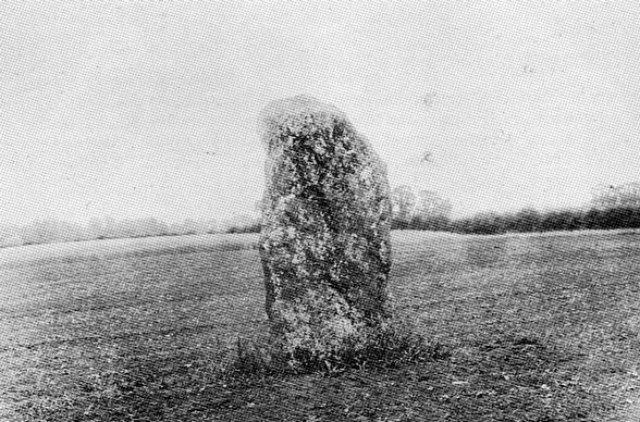
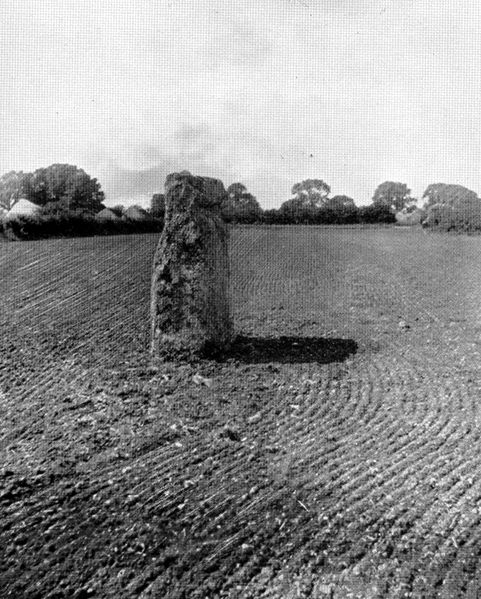
This might be the last surviving megalith of a Neolithic portal dolmen or some other burial tomb, rather than a stone erected on its own.

 Just outside the small hamlet of Dean, the Hawk stone stands in a field surrounded by yellow rape flowers, or by corn, ploughland or by the dea foliage of set aside. A footpath from Dean to Chipping Norton passes about ten yards away from it so it is possible to get a fine view without trespassing. From the nearest road, it can be seen just below the sky line.
It has a notch in it – produced by weathering. So far the Hawk stone has withstood damage from tractors, thanks to a conscientious farmer who has banked up the soil a little round the stone. This is my favourite stone. This might be the last surviving megalith of a Neolithic portal dolmen or some other burial tomb, rather than a stone erected on its own.
 Not far from the parish boundary on the Churchill to Chipping Norton Rd and marked on the large scale OS 1921 map. This is mentioned in OGS Crawford Long Barrows of the Cotswolds where he says “it seems not unlikely that it is of considerable antiquity.” It is not shaped, though damage from a hedge cutter may give it the appearance of being so. Not visible in 2002 and 2003 because of thick ivy and overgrowing hedge. In the winter of 2004 the hedge was cut so low that it became visible again.
This is also known as Boulters Barn stone. In the house nearest this stone in the triangle between the roads are a number of huge immovable stones. Maybe there was once a long barrow here of which these are the remains. A l930s history of the village also suggests there was a stone row in Sarsgrove. There exists a small row of stones just off the nearby footpath but these are so deeply embedded I think it unlikely that this is a prehistoric row.
This might be the last surviving megalith of a Neolithic portal dolmen or some other burial tomb, rather than a stone erected on its own.

 Just off the A 361 near Roundabout camp, not far from road to Chadlington. Overgrown barrow. The large stone is presumeably the blocking stone but it seems rather far from the rest. Robert Plot, author of The Natural History of Oxfordshire, 1677, writes: “And so again for the fortifications called Roundcastle, west of Begbrook Church, but in the parish of Bladen, and Lineham Barrow (between which and Pudlycot, a seat of the ancient families of the Lacy¹s, there is a passage underground down to the river) I can say little of them, but that in general Otis most probably they were made by the Danes (they being both round) but upon what occasion I could nowhere find.”

 Just outside the village, at a crossways. Three upright stones and a possible five fallen. Very dark because surrounded by trees. A sign by the Ministry of Works says this is a protected monument. Behind the stones is a concrete bunker entered from the top by a ladder. A large heap of human crap shows how we value our tombs. Once again these a stones which are said to go down to the stream to drink.
I think these are the stones mentioned by Robert Plot author of The Natural History of Oxfordshire, 1676 – “There stands also a stone about half a mile South-west of Enston church, on a bank by the wayside between Neat-Enston and Fulwell, somewhat flat and tapering upward from a broad bottom, with other small ones lying by it; and another near the Road betwixt Burford and Chipping-norton, which I guess might be erected for the same purpose with the two former as above mentioned (ie monuments to Saxons or ancient Britons dead in battle); Unless we shall rather think, both these and them, to be have been some of the Gods of the ancient Britons.¹ The stone on the way between Burford and Chipping-norton may be the Five Shilling Corner stone mentioned in The Old Stones of Rollright and District or possibly Lyneham Barrow stone.
This is a portal dolmen, consisting of a capstone balanced on orthostats of which at least two are set in an ‘entrance’ or “portal’ formation, sometimes with a third blocking stone. For good examples look at my Pembrokeshire page. This one is similar to the Rollright’s Whispering Knights.
 By the side of a row of cottages, the blowstone sits in its own little enclosure. It has lots of holes one of which is meant to make a loud noise. Richard Jefferies, the nature writer, referred to Othe shepherd¹s legend of Alfred the Great, and his horn of stone.” King Alfred is said to have blown the stone to summon help against the Danes. It may originally have stood on White Horse Hill.
I came here as a small child and remember this stone as three times the size! It is a domesticated stone with little fence round it, a little place for collecting money and for giving away an information sheet (not there in March). This stone has been preserved by being suburbanised, like the stone circle in the middle of a Scottish roundabout.
In the Victorian novel, “Tom Browns’ Schooldays” by Thomas Hughes, the Blowing Stone lay under a large oak outside a pub – “a square lump of stone, some three feet and a half high, perforated with two or three queer holes, like petrified antediluvian rat-holes.” Thomas Hughes describes what happens when it is blown – “Yes, here it comes, sure enough, a grewsome sound between a moan and a road, and spreads itself away ove the valley and up the hillside, and into the woods at the back of the house, a host-like awful voice.”
A splendid long barrow not far from the White Horse. This was originally a long barrow flanked with ditches with the unfleshed bones of at least 14 people. These were buried in a wooden chamber inside the barrow. Then a few decades later, the barrow was given a kerb made of stones and a façade of large sarsen slaps and dry walling. Inside a stone-build passage were the bones of eight individuals. This barrow was excavated in l965 and rebuilt into the monument we see today. Folklore had it that the barrow was Wayland the Smith’s blacksmith shop. If you left a penny and your horse there, it would be shod over night.
John Aubrey, perhaps influenced by this folkloric tale, wrote “about a mile from Whitehorse Hill on the top of the hill are a great many stones, which were laid there on purpose, but as tumbled out of a card; without any order; but some of them are placed edgewise. They are a good breadths.” On a different page, he wrote “And this great sepulchre called Wayland Smith is not unlikely to be a great and rude monument of Hengist or Horsa, for in their country remain many monuments like it.”
 A medium size stone on the track from Enstone to Clevely, past Drystone Hill house. Originally when Paul Bennett and Tom Wilson saw it, it was the other side of the stone wall, facing towards the stream. But now it is by the side of the footpath, simply placed without being buried in the earth, with its narrower end (which looks discoloured from the earth) at the bottom. The top is rounded and a bit crumbly. A dog walker told me “The farmer had removed it but they made him put it back.” As the track is too narrow for tractors it is probably reasonably safe. It is mentioned in The Story of Enstone ed by Graham Binns, Enstone Local History Group as “the ancient marker stone” !
 An oolite stone in the lower car park probably the oldest bit of Chipping Norton. Perhaps a marker stone on the track to Rollright stones, or maybe the last bit of an ancient long barrow long since covered by the town.
 The portal and blocking stone are visible. Unlike other long barrows, there is only a small sign of digging. It has been spared the Victorian amateur antiquarians! In l857, the keeper who found this barrow, and who presumably dug into it, found three skulls. The forest is closed except to Leafield villagers on Palm Sunday. A book of Cornbury reminiscences speaks of “the musical rock” in the forest, to which expeditions would be made. The long barrow megaliths do not fit the description. There is a less well preserved long barrow a bit higher up in Wychwood and one large but plundered one further on towards Swinbrook in a different part of the old Wychwood forest. No megaliths are visible in either of these.
 Just two stones protrude near a very big tree in the far end of a copse next to the A436 on the Oxfordshire and Warwickshire county border. (Prehistoric mouments are often used as bordermarks). There is a slight incline in the land and some further stones on the site may be those cleared from the ploughed field. George Lambrick in “Rollright Stones” (HBMC 1988) classifies the site as a simple portal dolmen tomb. It is not far from here that Crawford in 1922 thought he had found the Cornwell stone circle at SP 26602850. This is probably just an ornamental copse with stones cleared into it.
 This is built into the wall at Langley farm up from Fordwells, in the area which was once the forest of Wychwood. The farm house is on the site of the old hunting Lodge of the Forest, built for King John, one of the places where Henry V111 courted Anne Boleyn. The stone lies outside the 1300 AD medieval borders of Wychwood forest but outlying manors were afforested at various times, including Shipton under Wychwood, so it’s possible that it is some kind of marker stone. The owner told me “there was meant to be a tunnel from this stone to Minster Lovell hall.” This suggests that it is more than just a stray boulder used as a mounting block.

 Just at the back of the Fox pub near the village green is a footpath between the pub and a cottage. This spot is called Greenfield Gate on an 1854 map, The Forest and Purlieus of Wychwood by William Brian Wood, meaning the gateway or entrance to the forest. In the boundary inquisition in the first year of Charles 1, this is called Field Green gate – ie the gate at the green of the village, Field. A standing stone about up to two feet high at the highest point, two long and 10 inches thick, stands parallel to the pub wall and concrete has been poured into the gap between the wall and the stone. It may have been roughly shaped or it may be on its side. Grooves on the side suggest it has used as a “polissoir,” to sharpen scythes etc. Compare this with the Polisher stone in Wiltshire. Forest boundary records of the seventeenth century onwards mention Leafield, La Felde, Field town or just Field. This stone may have marked the entrance to the forest.

 This boundary stone is marked on the OS map at SLP 288 138. It is clearly marked on the l854 map The Forest and Purlieus of Wychwood by William Brian Wood and is also visible on A Plan of Wychwood Forest drawn l770 by Thomas Pride. You can just see it below the “O” of South Lawn on this map detail from the l854 map. The map suggests a sizeable stone. It is also known as Tudhill cross because a predecessor may have had a cross on it – there is no cross visible now. About 25 years ago it got in the way of farm machinery and was moved into the hedge. Then it was moved to where it now stands on the side of the road where the old Hit and Miss pub was. It is marked T W, which at a guess means Tudhill Wychwood. This is a shaped stone that looks to me relatively modern – perhaps at the time of disafforestation between l856-58. It probably replaced an earlier one marked with a cross, since it was also sometimes called Tudevin or Tudhill cross in the boundary descriptions.
Many of the other forest boundary stones are now lost – the Frethelstone was broken up to make a new road. “I was shown the spot where, until the disafforesting, it had long lain prostrate” says J R. Akerman in A View of the Ancient Limits of the Forest of Wychwood, Archaeologia l858. The Ladiham stone “a low flat boundary stone resembling the head stone of a grave and inscribed Ladiham Cornor’ was still extant in 1858 and may still languish in the woodland not far from Ladiham long barrow. The Hoarstone near Priestgrove, was cracked in several places. I have walked the ground and could not find anything but some large slabs the other side of the field, probably just cleared from the field. There were boundary stones between Low barrow and Fordwells which I have not found. I am still searching.
 This now stands at the back of Eynsham’s Catholic church, where Father John Tolkein gave it sanctuary. It was discovered in the ditch of a Bronze Age enclosure that preceded Eynsham’s Anglo Saxon abbey. It is oolitic stone, of the kind used in the Rollrights. The excavators, Oxford Archaeological Unit, were digging on the site of the old Abbey enclosure. The Bronze Age ditch may have surrounded a settlement or may have had a sacred purpose preceding Christianity. For more detail read Aelfric’s Abbey: excavations at Eynsham Abbey, Oxfordshire, 1989-92, by Alan Hardy, Anne Dodd and Graham D Keevil.
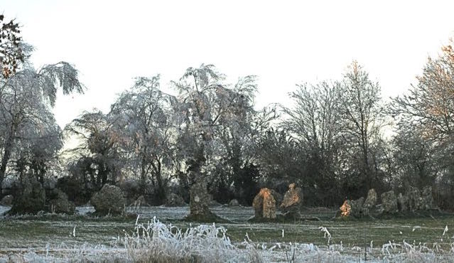

 The circle stands on a prehistoric trackway, surrounded by what were Neolithic and Bronze Age tombs. Richard Plot, in The Natural History of Oxfordshire in 1677 described it as “certain huge stones placed in a circle: the common people call them Rollrich-stones, and dream they were sometimes Men, by a miraculous metamorphosis turned into hard stones. The highest of them, which without the circle looketh into the earth, they call the King, because he should have been King of England (forsooth) if he had once seen Long Compton, a little town lying beneath… The other five standing on the other side, touching as it were one another, they imagine to have been Knights mounted on horseback, and the rest of the Army.” His illustration shows the circle with the King Stone just visible behind it.
 Plot, working from the manuscript of John Aubrey’s Monumenta Brittanica, argued against the idea that the stone circle was a burial monument. It could be, he thought, a triumphal pile set up to mark a victory, ” though I cannot but somewhat incline, yet am verily persuaded, that at the same time it might serve also for the election and inauguration of a King” He thought it might be the coronation circle for Rollo the Dane.
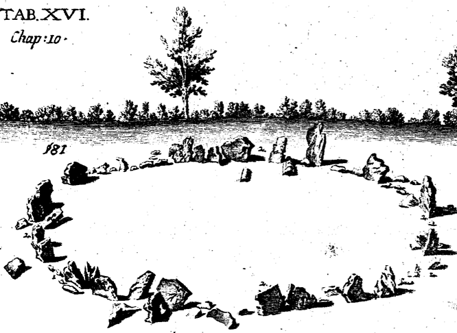
“A temple of the Druids of the first kind,… together with the Arch Druid’s barrow hard by,” is how William Stukeley described it in 1740. The stones, he wrote, were “corroded like worm-eaten wood, by the harsh jaws of time.” Stukeley’s illustration of the Whispering Knights shows the remainder of a mound around it and the circle in the background.
It is an unusual circle, consisting originally of many stones close enough to touch each other – a design found in Cumbria, Ireland and Wales. There are 22 stones left in the circle. For a complete account of the whole site, read The Rollright Stones: The archaeology and folklore of the Stones and their surroundings, by George Lambrick.

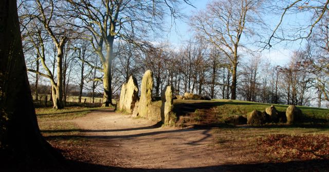
 On the same side and not far from the circle are THE WHISPERING KNIGHTS, four upright stones and a fallen capstone which would have been directly supported by three of them. This was a portal dolmen like Enstone. Look at my Pembrokeshire pages for better preserved ones. Across the road is the KING STONE, damaged by people who chipped off bits to use as amulets. It may have been a marker stone for a burial mound or the sole survivor from a portal dolmen. There is a Neolithic one the other side of the field boundary and two Bronze Age ones near the King Stone.